Quick facts
- Where
- Southern Morocco, on the track from Foum Zguid to the Chigaga dunes
- Drive from Foum Zguid
- About 40 km of track, about 1 h by 4x4
- Dimensions
- Dry lake about 13 km long
- Iriqui National Park
- 123,000 hectares, created in 1994
- Type of access
- By 4x4 track only
Lake Iriqui in figures
| Type | Sebkha: a dried Saharan lake with a clay floor |
|---|---|
| Length | Roughly 13 km |
| Lakebed | About 13 km × 11 km (measured by Ibn Tofail University during the 2024 flood) |
| Location | South of Jbel Bani, halfway between Foum Zguid and M'hamid El Ghizlane |
| Fed by | Three wadis: the Draa, the Oued Zguid and the Oued Mdawar |
| National park | Iriqui, created in 1994, around 123,000 ha |
| Last flood | September 2024: over 80 km², then about 146 km² of water |
| State today | Dry in 2025-2026 |
| From Foum Zguid | ≈ 1 h of 4x4 track (40 km) |
Why the lake is dry
- How it worked: for centuries, nearly every year, Draa floods from the High Atlas followed the foot of Jbel Bani and ended in this closed basin. Water covered the floor, and herds and birds followed it. In Foum Zguid, the oldest people remember years when there was fishing on the lake.
- The dam: El Mansour Eddahbi, built in 1972 upstream near Ouarzazate, holds back part of the floods for its own region.
- Droughts: they have come one after another over the decades.
- Sand: it has taken over about a third of the basin on the Chigaga side. A study by ANDZOA and Ibn Zohr University even shows that the bed of the Draa has shifted 2 km south, level with Dribila.
- The outcome: the Draa almost never reaches the lake now. What remains is a perfectly flat clay floor, laid down by centuries of floods and polished by the wind. On the edges, tamarisks draw on a water table that only exceptional rain refills: the lake is asleep, not gone.
Iriqui National Park
- Created and size: 1994, around 123,000 hectares between Jbel Bani and the Draa, among the largest protected spaces in Morocco.
- Provinces: Zagora and Tata.
- Habitats: two at once, the sebkha, listed as a seasonal wetland, and an acacia steppe around it. Dunes take up 46% of the park.
- People: a single village lived in all year round, Zaouit Sidi Abdenabi, with under a hundred inhabitants.
- Plants: over 130 species on record.
- Rallies: the region has drawn them for a long time. In 1973 the Rallye du Maroc ended a 200 km special stage from Irherm in Foum Zguid; the Africa Eco Race stopped there in 2014. Routes still run through the park, and the ANDZOA study advises moving them away from sensitive areas, the lake among them.
Wildlife: what is coming back, what you rarely see
- Dorcas gazelle: around twenty animals in 2018, over 450 today, after more than 200 releases.
- Addax: reintroduced since 2019; according to ANEF (June 2026), 55 to 60 live free and breed without help.
- Other steppe species: the houbara bustard and the fennec fox, for which the park is the last refuge in the region.
- Harder to spot: Barbary sheep, striped hyena, monitor lizard, chameleon and two horned vipers (Cerastes cerastes and C. vipera), on the park's official list but rarely seen.
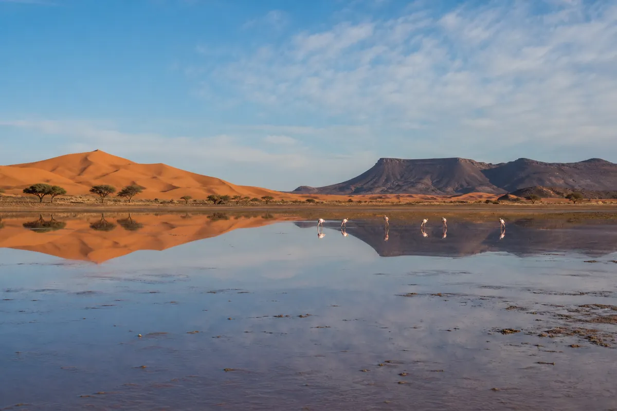
- Water birds: in rainy years, between January and March, flamingos and migrants land on the lake, a stone's throw from the dunes. Not at the moment: since the 2024 flood the lake has emptied.
Sights around the lake
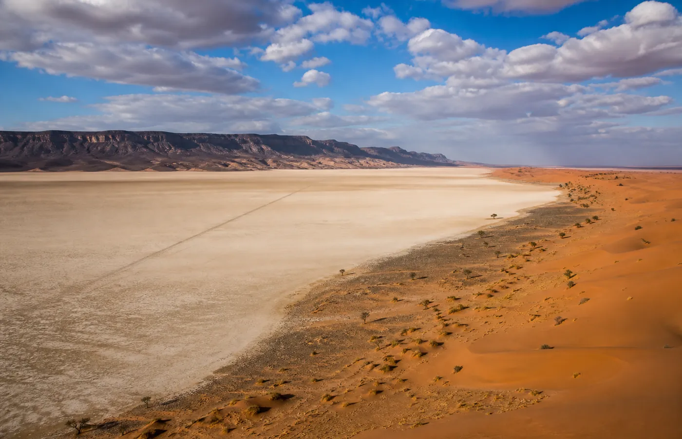
- The sebkha itself: about 20 minutes of crossing over a plain that is white from end to end, the high point of the day.
- The Moroccan Colorado (Jbel Madouar): a ring of red rock at the northern exit of the lake, best seen in low sunlight.
- The fossil plateau: ammonites and orthoceras you can see right on the limestone slab.
- Jbel Bani engravings: hunting scenes cut into the rock thousands of years ago, when the Sahara was still green.
- The steppe: raddiana acacias, tamarisks and, with some luck, gazelles early in the morning.
- The dunes: the erg starts on the eastern rim of the lake; most travellers combine the lake and Erg Chigaga on the same day.
Visiting Lake Iriqui: the options
No road and no public transport: you visit by 4x4, with a guide who knows the tracks.
| Starting point | Track to the lake | What it is like |
|---|---|---|
| Foum Zguid, our village | ≈ 1 h | The shortest and most varied: hamada, sebkha, Moroccan Colorado, and then the dunes |
| M'hamid El Ghizlane | About 2.5 to 3 h | Longer, by Erg Smar and the southern edge |
- For a day: our day out at Lake Iriqui, from €80 per person, nomad meal included.
- With a night in the dunes: the crossing is part of our Erg Chigaga trips with a camp night.
- By motorhome: on the N12, leave the vehicle in the village and come out for the day.
The crossing, step by step
- The 4x4 leaves the stony track and goes down a small bank.
- The jolting stops: all you hear is the hiss of the wheels, because the clay is smooth.
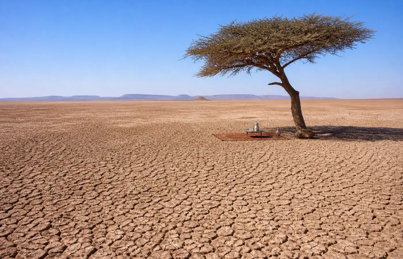
- Ahead of you, white for more than ten kilometres, and a horizon trembling in the heat.
- Distances start to deceive: a black dot might be an acacia ten minutes away or a vehicle an hour off.
- Ask for a stop in the middle, engine off, to listen to the silence: no photo captures that moment.
When the lake fills up
- Trigger: heavy rain over the Draa basin, in certain years only.
- How long: anything from a few weeks to a few months of shallow water over part of the sebkha.
- Birds: flamingos and migrants arrive within days, settling between dunes and mountain, a very long way from any coast. Photographers who were there at those moments describe it as the finest spectacle in the south.
- Live news: we cross the lake every week; if the year is a rainy one, message us before your trip and we will tell you what our guides have seen.
September 2024: the flood on record
- Cause: an extratropical cyclone swept across the north-western Sahara on 7 and 8 September 2024.
- Rain: from a few tens of millimetres to over 200 mm according to NASA, roughly a year's worth in two days. Its satellite images dated 10 September showed the sebkha of Iriqui park filling.
- Where the water came from: the north, by way of the Oued Mhasser, and not the Draa.
- Measurements: the Ibn Tofail University team (journal Land, 2025) recorded more than 80 km² of water after the first storm, then about 146 km² after the second.
- Life that returned: migratory birds absent from the lake's records since 1968, and triops, tiny crustaceans whose eggs wait for decades in the dry mud.
- How long it lasted: at the end of October 2024 the lake was still full and cut the track near the Titanic stop. It emptied afterwards: in 2025 as in 2026, our 4x4s find the sebkha dry.
- A common mistake: NASA never spoke of a first "in 50 years". The phrase comes from the press; the "30 to 50 years" from Morocco's weather service referred to the intensity of the rain, not the lake. The established fact: no water recorded on the lake since 1968.
If the water comes back, we will know fast: get in touch if your trip depends on it.
Stops on the lake track
A few addresses line the north-shore track between Foum Zguid and Chigaga. They are given to help you find your way, not as a ranking.
- Auberge Sahara Iriki: restaurant and terrace, on the north shore.
- The Titanic: a small hotel with a restaurant, further east; travellers call it "the famous Titanic campsite". We do not know how it got the name.
- Auberge Etoile Iriki, Café Désert Iriki, Restaurant Rimal Lac Iriki: other stops marked on maps of this sector.
- La Petite Maison du Lac Iriki: a family runs a guesthouse there, in Zaouia, on the shore of the lake.
- Not to be confused: the "Auberge Iriki" you find online is in town, in Foum Zguid. There is no bar on the lakeshore.
Lake Iriqui by bike
- Route: the track joining Foum Zguid and M'hamid; cyclists' GPS tracks can be found online, and some agencies sell mountain-bike trips on the lake.
- Surface: when dry, the clay is hard, fast and perfectly flat.
- Difficulties: soft sand near the dunes, no reliable water point, heat, headwinds.
- After rain: waterlogged clay, no way through, by bike or by 4x4.
- Tip: a support vehicle for water and bags makes the crossing much easier.
Where does the name Iriki come from?
- Amazigh name: Agelmam Iriqi; agelmam means "lake", as in Aguelmam Azegza or Aguelmam Sidi Ali.
- "Iriqi": no reliable source gives its meaning.
- Spellings: Iriki, Iriqui, Iriqi. In English it is Lake Iriqui or Lake Iriki; the national park's official documents write Iriqui.
Practical tips
- Timing: set off early; the morning is when the sebkha takes its finest light and when animals show themselves.
- After a big storm: no cutting straight across the lake; our guides then take the edge track, which is just as beautiful.
- Safety: bring more water than planned, and never head out alone in a 4x4 without knowing the track: the lake is immense and uniform, and phones get no signal there.
Questions and answers
What is the distance from Foum Zguid to Lake Iriqui?
About forty kilometres of track (40 km), or roughly 1 h by 4x4. It is the most direct way in: the white sebkha comes into view before the first hour is up.
Can an ordinary car get to Lake Iriqui?
No. No tarmac road leads to the lake, only tracks: you come by 4x4, or on a camel trek of several days. There are two starting points, Foum Zguid to the north and M'hamid to the east, and the drive is shortest from Foum Zguid.
Does Lake Iriqui have water in it right now?
No. In 2025-2026 it is a dry sebkha, a floor of white clay as far as you can see. A shallow layer of water only comes back in certain years, after heavy rain, and then draws migratory birds and flamingos. The last major flood dates from September 2024.
Was Lake Iriqui really flooded in September 2024?
Yes. Storms on 7 and 8 September 2024 put more than 80 km² under water, and about 146 km² after a second episode (Ibn Tofail University study, 2025). Migratory birds missing from the records since 1968 came back. The lake was still full at the end of October 2024; it has been dry since, and still is in 2025-2026.
Is crossing Lake Iriqui by bike doable?
Yes, on the track joining Foum Zguid to M'hamid. When dry, the clay floor is hard and flat; the traps are soft sand near the dunes and the lack of water. After rain, the lake can no longer be crossed.
Do you have to pay to enter Iriqui National Park?
There is no ticket office at the park entrance: you move about freely, but a guide who knows the tracks is still essential. With us, the route keeps to the permitted areas and avoids the sectors set aside for wildlife.
Which season is best for seeing Lake Iriqui?
October to April: soft light, pleasant temperatures and, in rainy years, water and birds between January and March. In summer you can still cross in the early morning, but by midday it is above 45 °C.