Tissint, the oasis of the salt waterfalls: the complete fact sheet
In short: Tissint is an oasis of Tata province on the N12 road; Foum Zguid is 67 km away (roughly an hour by car). Two reasons to go: the Attiq salt waterfalls, where a river loaded with salt drops into a pool ringed by palms, and the old ksar where Charles de Foucauld stopped in 1883, then again in 1884. The 2011 Martian meteorite bears the name Tissint, but it came down some 48 km from the village, towards the south-south-west. Tissint is our neighbour: here is what you will really find there.
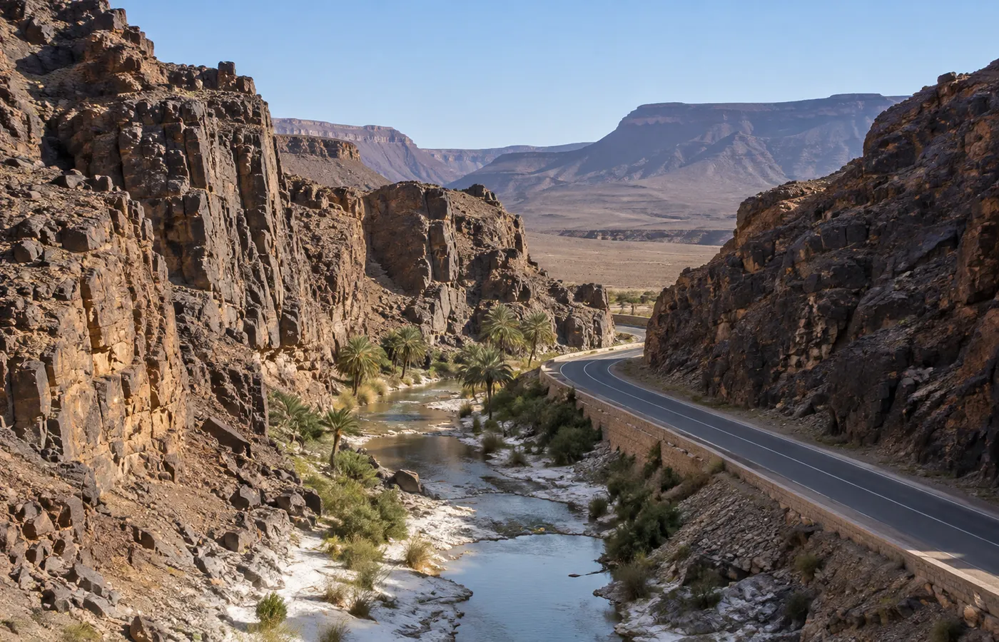
Tissint at a glance
| Status | Rural commune (Tata province, Souss-Massa region) |
|---|---|
| Spellings | Tissint, Agadir Tissint, Tissinnt |
| Location | On the N12, between Tata (about 70 km) and Foum Zguid (67 km) |
| Population | 8,216 for the commune, at the 2014 census |
| Sleeping and eating | A small town: we know of no reliable list of its hotels or cafés. Simplest plan: a night in Foum Zguid (see where to stay in Foum Zguid), with Tissint as a day out. |
The Attiq salt waterfalls: practical sheet
- Local name: in Tissint people say the Attiq falls; everywhere else you will read "Tissint waterfalls".
- The site: the river runs down the rock in steps, among palm trees, and ends in a natural swimming pool. Downstream, the water is shared out into irrigation channels for the palm grove.
- Official GPS point: 29.903051, -7.314031 (regional tourist office), a short walk from the village.
- The water: salty, and not fed by any hot spring.
- The flow: it varies with the season. The falls peak once the winter and spring rains have passed, and February and March are the months when they run full. Summer leaves a pool of salt water for swimming.
- In summer: set off early. In our area, July afternoons climb to 47 °C. How we plan those hot days: see our Sahara in summer guide.
Salt in Tissint: the name, the river, the banks
- The name: "Tissint" is the Amazigh word for "salt".
- The river: the Oued Tissint, which joins the Draa from the right bank. Upstream it takes in fresh water; it turns properly salty as it passes through the Jbel Bani.
- What you see: white tide marks left by floods along the banks, and crystals of salt on the ground, above all below the town.
- What we do not know: the exact geological origin of the salt. We have found no serious source on it.
Charles de Foucauld noticed the same thing in 1883. In his account, the river ran full in every season, yet its water was salty, so people drank rainwater stored in hollows of the rock. Fish of up to 40 cm lived in it, and locals thought it was fed by the sea. At the head of the palm grove a dam sent the water into a maze of channels, some 2 m wide, without a single khettara. For sheer volume of running water, he judged, Tissint had no equal among the oases he knew.
The oasis and its five ksour
- Foucauld's portrait: he counts it among the biggest oases in the Moroccan Sahara, a thick palm forest filling a basin enclosed by the Bani and a circle of hills.
- A local saying: he reports that people named Tata, Akka and Tissint as the three great oases of the region. Tata had the most inhabitants, Tissint the most palms.
- Dates: mainly jihel, which he rated very good here. Nothing grew beneath the palms, since they took all the water.
- The ksour in 1883: five. Agadir, the largest (500 families), then Aït ou Iran, Bou Mousi, Ez Zaouïa and Taznout. In wartime, Agadir and Bou Mousi served as refuges.
- Ruins: four ksour, all abandoned: one at the far southern end of Foum Tissint, the other three up on the summit of Jbel Taïmzour.
- Search terms: "Aït Ouirane" or "Tissint kasbah" lead to these fortified villages. The old Ksar Tissint is one of them; a travel guide describes it as built against a cliff face. Two more, Tissekmoudine and Agadir Aserghine, stand close by.
- Trade: caravans once halted here on the road between the Souss and Sijilmassa. The town's other reputation: medicinal plants (sage, lavender, wormwood, thyme), once sold as far away as Libya, Egypt, Senegal, Niger and Algeria.
Charles de Foucauld's two stays (1883 and 1884)
- The journey: Foucauld travelled through Morocco in the guise of a Jew, in the company of Rabbi Mardochée Abi Serour.
- 14 November 1883, 10 a.m.: he reaches Agadir, the largest ksar of Tissint.
- 16 November 1883: a band of 400 Berâber loots the western gardens of the oasis; he leaves for Tata.
- 31 March 1884, 7 a.m.: back from Mogador, he enters Agadir once more.
- 6 April 1884, midnight: he sets off over the Tizi n Haroun towards Taznakht. Famine had stopped him from finding an escort through Foum Zguid.
- In sum: two brief stays, not several weeks. His book, Reconnaissance au Maroc (published 1888), won him the Société de Géographie's gold medal.
- To visit: his house is open to visitors, roughly 400 m downstream of the spring.
2011: the meteorite that came from Mars
- The fall: 18 July 2011, around 2 a.m. In Tata province, people see a dazzling fireball and hear two sonic booms. One witness says it changed from yellow to green and looked as if it broke in two.
- The fragments: from October 2011, nomads collected dozens of pieces, from 0.2 g to 1,282 g each. Estimates of the total mass vary with the source, from about 7 kg to 15 kg.
- Origin: Mars. A basaltic shergottite, its glass still holding pockets of Martian atmosphere; an impact threw it into space roughly 0.7 to 1.1 million years ago.
- Rarity: only the fifth Martian meteorite whose fall was witnessed, and the first since 1962. For Caroline Smith of London's Natural History Museum, it may well be the most significant meteorite fall of the past hundred years.
- Where the pieces are: that museum acquired a 1.1 kg stone, one of the biggest, in February 2012. Others went to Chicago's Field Museum (six fragments, 321 g), to Vienna and to private collections.
- The exact place: not Tissint. The strewn field is out on the hamada, near the El Ga'ïdat plateau and the Oued El Gsaïb: roughly 50 km east-south-east of Tata, and 48 km or so south-south-west of the village. Tissint lent its name only because it was the closest settlement. Neither at the falls nor in the ksar will you see anything linked to it.
Tissint in the Jbel Bani
- The mountain: a narrow crest of black rock, some 500 km long, from Zagora to Tan-Tan.
- The foums: Draa-bound rivers have sliced gorges through it, called foums, each with its oasis: Foum el Hisn, Akka, Tata, Tissint and Foum Zguid.
- Foum Tissint: road and river pass through the gorge side by side. Foucauld measured 150 m from wall to wall, 40 m of it taken up by the riverbed, and describes cliffs of glossy black rock.
- Jbel Bani Geopark: the geopark of Tata province, which Tissint belongs to. Between the Draa and the Bani, it counts over 80 sites with rock engravings.
- A site near Tissint: to the south-west, about 13 km of track and then 400 m on foot up to a ridge. What is carved up there we do not know, so we say nothing about it.
- The engravings we show: those on the Bani near Foum Zguid, on the final day of our four-day grand tour of the desert.
One day in Tissint: a plan
- The Attiq falls first, and their pool, especially in summer, before the heat.
- Then the old ksar and Foucauld's house, around 400 m downstream of the spring.
- A stroll in the palm grove, on foot, following the channels.
- Foum Tissint, the gorge crossed by the N12.
- The medicinal plants that made the town's name (sage, lavender, wormwood, thyme).
- With time left: the Akka n'Aït Sidi oasis, or two other fortified villages, Agadir Aserghine and Tissekmoudine.
Allow half a day if you keep to the ksar and the falls. Add the surroundings and it becomes a full day, so leave Foum Zguid early and plan to be back by evening.
Access from Foum Zguid and elsewhere
- From Foum Zguid: 67 km and about an hour on the N12, westwards in the direction of Tata. Tarmac the whole way, so no 4x4 and no guide needed; an ordinary car is fine.
- Reaching Foum Zguid first: roads and buses from the big cities are in our guide on how to get to Foum Zguid.
| Starting point | Figures | Route |
|---|---|---|
| Foum Zguid | 67 km, roughly 1 h | N12 west (direction Tata) |
| Tata | Roughly 70 km | N12 east (direction Foum Zguid) |
| Ouarzazate | 2.5 h and 160 km as far as Foum Zguid, then 67 km | The Foum Zguid road, then the N12 towards Tata |
| Marrakech | 5 h and 310 km as far as Foum Zguid, then 67 km | Taznakht, Foum Zguid, then the N12 |
| Agadir | Route published by the regional tourist office | Taliouine on the N10, Akka Ighane on the P1743, then the N12 |
Combining Tissint with the desert
- Why it is not in our catalogue: our 4x4s head south out of Foum Zguid (Lake Iriqui, then Erg Chigaga, also written Chegaga), whereas Tissint lies west of the village, along the tarmac.
- Option 1: on your own, in your own car, before or after your desert trip.
- Option 2: we add it to a tailor-made trip.
- Two nights in Foum Zguid: day 1, Tissint; day 2, a day out at Lake Iriqui, or leave straight away for a night in the dunes.
- Arriving from the west (Tata, Agadir): Tissint is on your way. A midday swim, the evening in Foum Zguid, off to the desert the next morning.
- For the rest of your stay: things to do in Foum Zguid, our local list.
GPS coordinates of the places in this sheet
Your reference points for the day are below. For the overall picture (the N12, Lake Iriqui, Erg Chigaga), our map of the desert around Foum Zguid shows everything on one screen.
| Place | Reference | Coordinates |
|---|---|---|
| Attiq falls | Official point, right next to the village | 29.903051, -7.314031 |
| Tissint commune | 67 km by the N12 from Foum Zguid | 29°54′02″ N, 7°19′13″ W |
| Foum Zguid centre | Starting point of our trips | 30.0819, -6.8759 |
| Meteorite strewn field | Some 48 km to the south-south-west of the village | no precise point published |
Questions and answers
Whereabouts in Morocco is Tissint?
In Tata province (Souss-Massa region), where it is a rural commune. The village lies on the N12, almost exactly between Tata (about 70 km) and Foum Zguid (67 km).
What is the distance from Foum Zguid to Tissint?
About an hour's drive: 67 km on the N12, heading for Tata. There is tarmac from end to end, so any ordinary car will manage.
Are the Tissint waterfalls salt water?
They are. In Amazigh, Tissint means "salt", and the river picks up a marked salt load as it cuts through the Jbel Bani. Nothing here comes from a hot spring: what you see is a salty river that drops down through the palm grove in a series of steps.
Is swimming possible at Tissint?
Yes: at the foot of the Attiq falls, a natural pool takes swimmers, summer included. In the hot months, come early. For falls carrying a lot of water, pick February or March, once the rains have fallen.
Is the spot where the Tissint meteorite landed open to visitors?
It came down out on the hamada, not on the village: some 48 km to the south-south-west. Its fragments now sit in museums (Chicago, London, Vienna) or with collectors, and nothing in the village itself relates to the meteorite.
Aït ou Iran, or Aït Ouirane: what is it?
One of the five ksour of the oasis that Charles de Foucauld recorded in 1883. The other four: Agadir, Bou Mousi, Ez Zaouïa and Taznout.
Which season suits a visit to Tissint best?
For pleasant temperatures, October to March; for full falls, February and March. In summer an early-morning swim still works, before the heat sets in.
Do you offer an excursion to Tissint?
It is not in our catalogue: our trips head south from Foum Zguid, to Lake Iriqui and Erg Chigaga. Two ways round that: drive there on your own the day before or after the trip, or let us add it to a tailor-made itinerary.